2.08.19 – One of the last ‘acts’ that Mike DeWine did as Ohio Attorney General was to file a motion to dismiss the gerrymandering lawsuit that is in front of a three-judge panel in federal court in Cincinnati. DeWine continued his penchant for wasting Ohioans tax dollars. Fortunately, late today the same three-judge panel dismissed DeWine’s request. Thus, the lawsuit will continue as scheduled on March 4 moving forward to fairer congressional districts.
Below are links to important articles about this suit.
- Gov-elect Mike DeWine files motion to dismiss Ohio gerrymandering lawsuit | cleveland.com
- Federal judges reject state of Ohio’s request to delay gerrymandering trial | cleveland.com
- Federal judges were right: Ohio gerrymandering lawsuit should go forward – Editorial | cleveland.com
- The mathematicians who want to save democracy | Scientificamerican.com

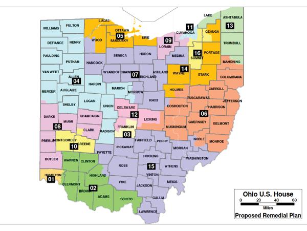
Proposed new Ohio congressional district map submitted to federal court.
(U.S. District Court Southern District of Ohio)
The plaintiffs, including the Ohio League of Women Voters, have argued that Ohio’s congressional map violates the constitutional rights of voters by “entrenching partisan advantage” — the result being 12 predictably Republican districts and four predictably Democratic districts in a state closer to 55-45 politically.
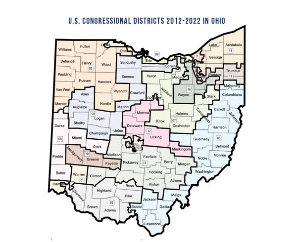
The current map, drawn with Republicans in nearly full control of the process in 2011, makes little geographic sense, and leaves many people without a representative who lives in their area. Some districts meander for 100 miles or more across the state.
Cuyahoga County, for example, has parts of three congressional districts, but none wholly contained within the county. One district, in fact, stretches south to near Canton. One Lorain County district stretches south to Columbus suburbs before extending west almost to Indiana.
Ohio’s current congressional map.
The map proposed in the court filing, shown at the top of this story, appears to make more geographic sense throughout the state.
For instance, the state’s three largest counties — Cuyahoga, Franklin and Hamilton — would all have one wholly contained district. The remaining areas would be shared with other counties.
A three-judge panel in Cincinnati has scheduled a trial for March 4 for the suit, originally filed in May. The judges have allowed numerous Republican lawmakers and voters to intervene in the lawsuit. Named as defendants were elected leaders, including Secretary of State Jon Husted and Gov. John Kasich, two Republicans were outspoken against gerrymandering, although Kasich signed the disputed map into law.
Husted, who is now running for lieutenant governor, questioned the timing. “Why did they wait six years to file a lawsuit challenging the maps? These groups should respect the will of Ohio’s voters who overwhelmingly approved a constitutional amendment earlier this month that established a new, bipartisan process for drawing congressional districts starting in 2021,” he said in a statement released after the suit was filed.
Ohio voters in May approved a change to the Ohio Constitution that will govern how the Ohio map will be drawn in 2022, after the next census. The change includes new limits on how counties could be split and the influence of any one party on the process.
However, advocates involved in the suit hope hope a ruling will lead do a new map before then.
Cleveland.com reporter Eric Heisig contributed to this report.


